

Never miss what is happening in Sussex County
Events, new openings and weekend plans from Newton to Vernon, Sparta to Stanhope. Straight to your inbox, free.
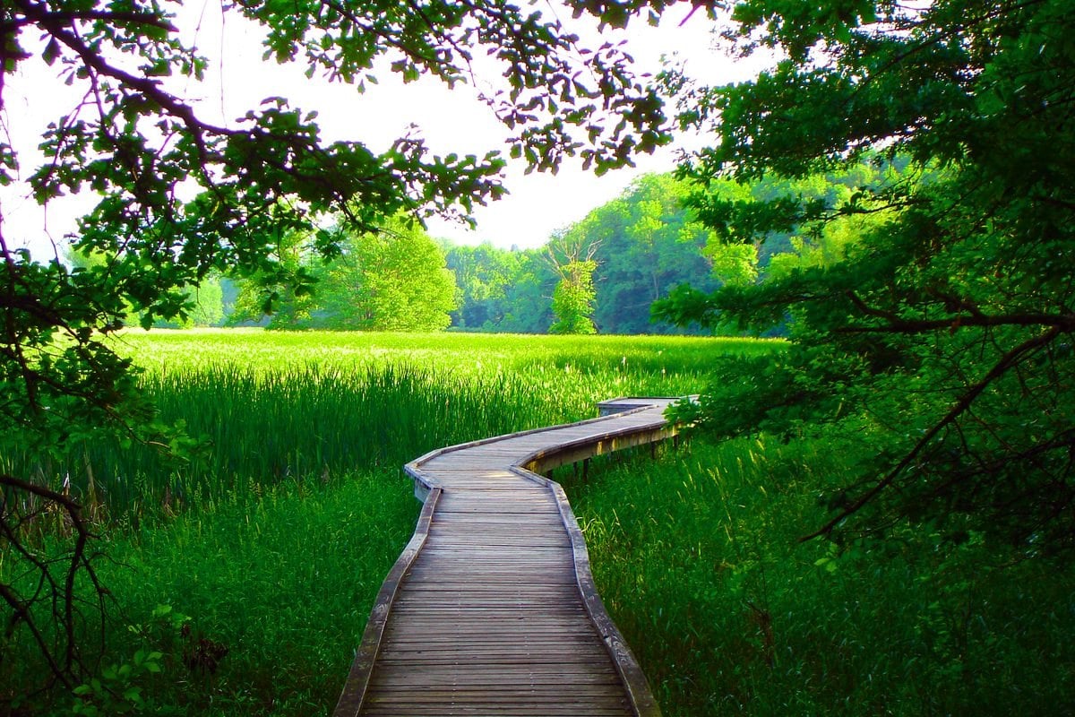
The Appalachian Trail boardwalk Vernon NJ hikers love, known as the Pochuck Boardwalk, carries the white-blazed A.T. across the Pochuck Creek wetlands on a raised wooden walkway with a suspension bridge in the middle. It is one of the easiest and most popular stretches of the entire trail in New Jersey, and it sits just a few minutes from one of the hardest short climbs in the county: the rock steps hikers call the Stairway to Heaven, which rise up Wawayanda Mountain to Pinwheel’s Vista.
Here is the short version. The boardwalk is a flat, easy walk of about 2 miles out and back from the Route 517 crossing, per the Appalachian Trail Conservancy. The Stairway to Heaven is a 2.6-mile out-and-back from the Route 94 lot with about 900 feet of climbing, rated strenuous by the New York-New Jersey Trail Conference. Parking is limited at every access point, so plan ahead, and leash your dog on both.
What the Pochuck Boardwalk is
The boardwalk lifts the Appalachian Trail over the low floodplain of Pochuck Creek, which the Trail Conference notes the National Park Service has designated one of the most valued wetlands in the country. The ATC calls it the longest elevated boardwalk built to date on the A.T., running over more than a mile of wetland. It was built by volunteers led by the Trail Conference and the Appalachian Trail Conservancy, and it crosses what was once a prehistoric lake between Pochuck Mountain and Wawayanda Mountain.
The ATC lists birds including bald eagles, plus turtles, snakes and frogs, among the wildlife that live in the wetland, so bring binoculars in spring and fall.
What the boardwalk walk is like
Starting from Route 517 and heading north on the A.T., the ATC hike description lays out the route like this:
- A short gravel path descends from the road to the start of the boardwalk.
- At about 0.4 mile the boardwalk dips briefly into the woods, where there is a gap in the boards and a wide, rocky dirt path, then returns to open wetland.
- At about 0.7 mile you reach Pochuck Creek. Eighteen stairs lead up to the wooden suspension bridge over the creek.
- The boardwalk continues about 0.2 mile past the bridge. Most people turn around there and return the same way, for roughly 2 miles total.
The ATC rates it easy. It notes the boardwalk itself is wheelchair accessible, but there is no nearby ADA parking, the entrance from the road has a narrow gap through the guardrail and a short gravel descent, and the rocky section near 0.4 mile can be a barrier. The boardwalk is fully exposed to sun and wind, so a hat in summer and a warm layer in late fall go a long way.
The Stairway to Heaven climb to Pinwheel’s Vista
On the other side of Route 94, the A.T. leaves the valley floor and climbs Wawayanda Mountain inside Wawayanda State Park. The Trail Conference hike description lists it at 2.6 miles out and back, about 900 feet of ascent, roughly 2.5 hours, and a strenuous rating.
From the Route 94 lot, the trail starts on stone and log steps, passes a kiosk, goes under power lines, and crosses a field of young cedars before skirting boulders that have tumbled off the mountain. Two long switchbacks follow. After about 250 vertical feet in 0.3 mile you reach Annie’s Bluff, which looks down on Heaven Hill Farm. Higher up, the rock steps nicknamed the Stairway to Heaven lead to a large cairn. From there a blue-blazed side trail takes you to Pinwheel’s Vista.
The payoff is a wide view of Vernon Valley directly below, with Pochuck Mountain across the valley. On a clear day the Trail Conference says you can pick out the Shawangunks and the Catskills to the north. Return the same way on the A.T.
The Trail Conference is clear that the treadway is very rocky, so watch every step, and that Annie’s Bluff has a steep drop right beside the trail. Keep kids close there.
Where to park
The Trail Conference destination page lists four access points. Parking is the single biggest headache here, so pick your lot before you leave home.
- Route 517 shoulder (GPS 41.235761, -74.480470): the closest start to the boardwalk, but parking is very limited and allowed only where signs say so. The Trail Conference warns that cars parked elsewhere on Route 517 or nearby side streets may be ticketed.
- Canal Road (South) lot (GPS 41.226677, -74.468951): a small dirt lot for up to 15 cars. The middle of Canal Road is closed to traffic, so approach from the south via Maple Grange Road.
- Canal Road (North) / Bucky Lane lot (GPS 41.231688, -74.462125): a small dirt lot for up to 10 cars, reached from the north via Prices Switch Road.
- Route 94 lot (GPS 41.219347, -74.455087): a small dirt lot plus a wide shoulder with room for about 20 cars. This is the trailhead for the Stairway to Heaven, about 0.6 mile north of the Maple Grange Road intersection per the Trail Conference.
The Trail Conference recommends parking at Canal Road or Route 94 and hiking west to the boardwalk. You skip the worst of the Route 517 parking crunch and get a longer, more scenic walk. Parking from Route 94 also lets strong hikers do both sections in one outing: the boardwalk to the west and the climb to Pinwheel’s Vista to the east.
Know before you go
- Dogs: Allowed on both sections, on leash, per the Trail Conference.
- Crowds: The boardwalk is heavily used, especially on weekends and on warm evenings after work. Lots fill early, so arrive in the morning or on a weekday.
- Stay on the boards: Remain on the boardwalk to protect the wetland.
- Footwear: Sneakers work for the boardwalk. Wear real hiking shoes for the Stairway to Heaven, which is steep and rocky.
- Water and layers: There are no facilities along either section. Pack water, and expect it to be windier and cooler at Pinwheel’s Vista than in the valley.
- Emergencies: Call 911. To reach the Wawayanda State Park office, call (973) 853-4462, per the NJDEP park brochure.
Make a day of it: our guide to the best restaurants in Vernon has lunch covered, and through November 8 the Great Pumpkin Festival at Heaven Hill Farm is running on Route 94, the same farm you see from Annie’s Bluff. For more leaf-season ideas, see our roundup of fall foliage hikes in Sussex County.
Frequently Asked Questions
How long is the Appalachian Trail boardwalk in Vernon NJ?
The ATC lists the Pochuck Boardwalk hike at about 2 miles out and back from Route 517, with the boardwalk itself covering more than a mile of wetland.
Where do you park for the Pochuck Boardwalk?
Options are the Route 517 shoulder (signed spots only), the Canal Road South lot (up to 15 cars), the Canal Road North/Bucky Lane lot (up to 10 cars) and the Route 94 lot (about 20 cars). The Trail Conference suggests Canal Road or Route 94.
How hard is the Stairway to Heaven hike?
The Trail Conference rates it strenuous: 2.6 miles out and back with about 900 feet of climbing on rocky trail, roughly 2.5 hours.
Are dogs allowed on the Pochuck Boardwalk?
Yes. Dogs are allowed on leash on both the boardwalk and the Stairway to Heaven.
Is the Pochuck Boardwalk wheelchair accessible?
The ATC says the boardwalk itself is wheelchair accessible, but there is no nearby ADA parking, the entrance has a narrow guardrail gap and gravel descent, and there is a rocky dirt section near 0.4 mile.
Get Sussex County in your inbox. Our free weekly newsletter rounds up the best hikes, events, food and things to do across all 24 towns. Sign up free here.
Primary sources for this guide: Appalachian Trail Conservancy, Pochuck Boardwalk hike; NY-NJ Trail Conference, Pochuck Boardwalk Section of the Appalachian Trail; NY-NJ Trail Conference, A.T. Stairway to Heaven; NJDEP Wawayanda State Park brochure.
Featured photo: the Appalachian Trail boardwalk through the Pochuck Creek wetlands in Vernon. Photo by Maro Masparian, America’s Byways (Federal Highway Administration), public domain.
Have a Sussex County event coming up?
Share it with Sussex County.
Festivals, fundraisers, 5Ks, school nights, grand openings. Send us the date, time, place and a flyer, and our team will reach out about getting it in front of Sussex County.
Enjoying our Sussex County coverage?
Add us as a preferred source and our stories show up higher in your Google results.
Add as a preferred source